Showing posts with label The Roaches. Show all posts

12/05/2012 - Training on The Roaches

Following a good evening walk on Wednesday where Mark, Martin and Lee were joined by Support Team member Simon (managing to shave 6minutes off their previous time), plans were made for Saturday's 6 hour walk to The Roaches and back.

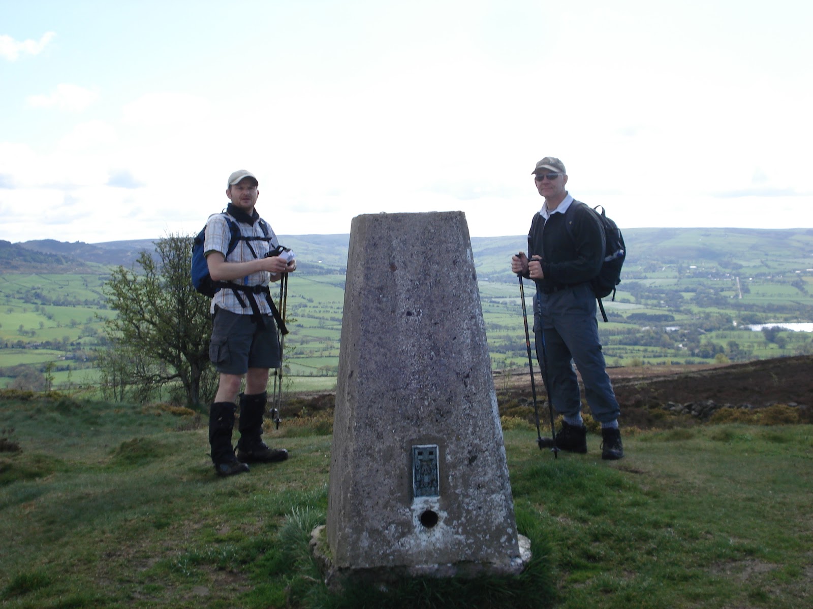
The trig point on Gun Hill with The Roaches behind
Meeting up at 9am at the now infamous Knot Inn in Rushton Spencer, Mark, Lee and Martin set off into the unknown as none of us had ever taken this route before. Despite the apparent good weather for a change, it rapidly became clear that the Peak District had received more than its fair share of the recent heavy rainfall, fields had become boggy and thoughts turned to whether or not we should have donned boots instead of trail shoes but we persevered on the steady climb to the top of Gun Hill which seemed to pass very quickly.

To add to the boggy fields problem, we seemed to come across more and more electric cattle fences blocking our path with no convenient means of unhooking. We have developed a knack for dealing with these using our walking poles. While the shafts are aluminium the rubber handles keep us insulated allowing the wire to be lifted or pressed down allowing teammates to pass. Martin always seems all to willing to test this out and sacrifice himself for his teammates in this respect.

Hen Cloud getting closer
From the top of Gun Hill we descended to Tittesworth Reservoir, a place where Mark has brought his kids to feed the ducks on previous occasions but as this marked the low point and Hen Cloud was becoming ever more present we started our upward path. The plan was to go around the base of Hen Cloud and ascend from the far side, coming over the top and down towards The Roaches. As we crossed the ford near Upper Hulme, we lost all sign of the footpath we needed to take, no signs, no desire lines, no stiles and no gates. We retraced our steps and still nothing, so a quick examination of the map and we changed the plan to approach Hen Cloud from the front and walk round the base of the hill itself which meant walking back the way we had come.

The cliffs on Hen Cloud
Noting signs warning us that some paths were closed due to nesting Peregrine Falcons we wondered whether this would affect our plan but it didn't and they remained safely undisturbed in their nests. This route took us past Roaches Hall which looked a nice little place and we soon started our ascent to the top. Arriving at the top, we took in the view and the rugged beauty of this place and after 3hours of walking decided this would be a good spot for a a bite to eat so setting aside 10 minutes we tucked into sandwiches, Lucozade, peanuts and Polly's 'energy cake' which she had dispatched Lee with. After throwing in the now customary foot check for Mark, we were soon descending Hen Cloud and heading up The Roaches.

Climbers on The Roaches
The Roaches is a very popular with walkers and climbers alike and today was no exception as the trails and cliff faces were teeming with people. At one point we could see Lee eyeing up the climbers taking the 'vertical' route and pondering but we managed to drag him away before he could come up with another sadistic test for us.

We passed Doxey's Pool where legend has it a mermaid lives and entices victims into the depths of this 'bottomless' pool. Though no evidence existed today, we didn't linger too long and carried on to the trig point passing some interesting windswept and eroded rocks on the way.

No mermaid at Doxey's Pool today
Once passed the trig point we were again coming down and the route had been planned to take us through Lud's Church somewhere Martin and Lee had never been before and a place steeped in legend. The route was fairly arduous as the trail was boggy, fast flowing rainwater had eroded the peat to expose tree roots and high winds had brought trees down across the path making it heavy going. Dropping carefully into the chasm in the rock, we worked our way along the bottom, stopping to check on the geocache hidden there (a hobby of Mark's) and sign the logbook before working our way to the very muddy exit.

The Lud's Church chasm

Back on the trail which was in much better condition we worked our way back towards the end of The Roaches and along the boundary of Swythamley Hall and noted a number of large felled trees and wondered whether the recent Oxfordshire tornado had detoured this way. In the valley below we noted a building and reading the letters on the side identified th as the 'Wincle Brewery'. A detour was debated to the brewery but then we felt better of it as we we had pie and chips awaiting in the Knot Inn. It was at this 22km point Mark suddenly got an inconvenient twinge in his right calf but he managed to stretch it out.
We completed this 27.5km with 663m climb training walk in 6hrs 12minutes, a little longer than we had been looking for but put this down mainly to the conditions underfoot and negotiating the many electric fences.

05/05/2012 - Trailwalker Prep Session and Training on The South Downs - Pt2

Our plan following the Prep Session was to train on the Trailwalker route starting at Checkpoint 5 (Washington) to Checkpoint 7 (Devil's Dyke). Our logic behind this is that as we previously discussed in our blog, Stage 7 is arguably the hardest section of the trail with Stage 6 not far behind. It's likely that these stages will be done as we hit nightfall, we'll have already walked a long way and then we'll have to face the biggest climb on Trailwalker to the top of Truleigh Hill.

Mark was also taking the opportunity to test his Spot Messenger - a device which enables friends and family to track the team, and allows messages to be sent confirming all is OK or even issue an SOS (not that we're planning on using it) all by satellite where mobile signal is absent. In tracking mode it issues a location every ten minutes which should help the Support Team anticipate our arrival. The track can be seen here (well until we delete it anyway).
 
Chactonbury Hill
To do these stages presented somewhat of a logistical problem. Simon was going to walk stage 6 with us and then retire so he needed to leave a car near to Checkpoint 6. Mark, Lee and Polly drove to Devil's Dyke and arriving at the car park were blown away by the stunning view. It's a pity that it will be dark when we get here on Trailwalker. Leaving Lee's car in the car park, the gear was loaded onto Mark's and we headed for the Car Park near Checkpoint 5 collecting Simon on the way. This process took us nearly 2 hours. One thing we did note was the traffic congestion the closer we got to the coastal roads, it was Saturday and the out of town shopping parks were busy - this is likely to be worse in Summer so perhaps routes for the Support Team need to avoid.

Lee and Polly on the trail climbing Chactonbury Hi
Arriving at the car park at Washington on the East side of A24 presented a further small logistical problem. We had to cross over the A24 Dual Carriageway to find Checkpoint 5 but as this is actually in a field which is out of bounds during non-Trailwalker hiking we had to take a detour round it in order to reach the start of the route. This at least gave us a brief taste of the trails which given the recent rainfall were well churned up by hikers, horse riders and cyclists. We imagined what they would be like after a couple of thousand people had trudged it and decided it was probably a good argument for an earlier start.


Pond or path? You decide...
As we reached the southern side of the field, Chactonbury Hill came into view as we descended back to the A24 crossing the road using the public footpath through North Side Farm rather than being able to access the official Trailwalker road crossing and we were soon back on the official route, climbing the hill. The trail at this point was vehicle width, very chalky and full of flint. We could imagine the chalk becoming very slippery when wet (sounds like a good name for an album) and the uneven flint was felt with each footstep. The climb was steady and not particularly arduous and we were soon at the top and on the gradual gradient down again.

Taking note of where Checkpoint 6 will be we decided to take a 10minute break to simulate the stop, have a quick snack and Mark took the opportunity to change socks as well (well the simulation had to be accurate) while Lee timed the stop (yes - we trusted him with a clock!). The opportunity was taken to scoff a piece of Polly's 'Energy Cake' as well. 

The ten minutes over, we headed from Checkpoint 6 and crossed the River Adur where we said farewell to Simon (he counted us out and will count us all back in again) as he departed for his car and we trudged along the muddy path at the side of the river observing a large group of young swans gracefully swimming against the strong current.

Crossing the Rubicon, sorry, I mean Adur.
At near sea level, the River Adur marks the low point of the trail and weaving our way through Upper Beeding we found the track which would take us up to the top of Truleigh Hill - a 200m climb the biggest on Trailwalker. The track is quite straight and the initial section is the steepest part , this gradient starts to ease but just seems to prolong the climb to the top where the masts sit. The masts are a very useful landmark for gauging how much further it is to the top. Once at the top, unfortunately it's not downhill to Devil's Dyke. There are a series of rolling hills between you and Checkpoint 7. We passed the sign marking 'Fulking Escarpment' taking the opportunity to remark something similar as we went into the next climb.

Masts mark the top of Truleigh Hill - a good landmark
Polly noted a walker in the distance and set the team a target of overhauling this lone walker.  We seemed to gain ground on the uphill sections only to find this lone walker was running the downhills so we lost ground again. Eventually and only as we approached Checkpoint 7 did we eventually catch up only to find this was a fellow Trailwalker (The Champagne Chicks) who had already been walking most of the day on her own and had decided she would go to Checkpoint 8 before calling her boyfriend to pick her up! We bid her good luck as we turned at the National Trust Devil's Dyke sign and headed to the Car Park near the Devil's Dyke pub and managed to avoid the temptation of a quick pint before heading to our digs.

Devil's Dyke distant with rolling hills in between.
We completed the 23.36km in 4hrs 34minutes with a climb of 492m this was a good way ahead of the 5hrs we thought it would take us (mainly due to Polly 'Pace Setter' methinks). The stats for this walk are here.

It was great to finally experience the South Downs and the scenery we have seen so much of in photographs provided by other teams. We were amazed how far you can see inland to the North and out to sea in the South. It was well worth the effort to come down and do some of the course knowing the next time it will be the real deal. 


From hereon in, our training ramps up again as we add an hour to our long walk each week up to the event. Our next training walk takes us back to The Peak District and a route taking us from Rushton Spencer, over Gun Hill, down to Tittesworth Reservoir, up Hen Cloud, along The Roaches past Luds Church and back to Rushton Spencer. This 28km walk should give us nearly 700m of climb and hopefully great views if the weather is half decent.

21/04/2012 - Training Walk #15 - Conquering The Matterhorn (of The Peak)

Shutlingsloe Hill - The Matterhorn of The Peak
With Gurkha Training cancelled, we had hastily arranged a training walk which we felt would be an adequately punishing replacement. On previous training walks to Croker Hill, we had noted an oddly shaped peak further out into the Peak District. Lee had referred to this as 'Table Top' but reviewing the OS did not provide any hills by that name.

After a careful bit of comparing contours we reckoned this hill must be Shutlingsloe Hill and further Googling led us to find this was the third highest hill in The Peak District and nicknamed 'The Matterhorn of The Peak' because of its steep sides resembling the orignal.

Perfect we thought - throw in another hill and another and another and suddenly we were looking at 21km and over 700m of climbing - the most climb we have done to date and about 30% of Trailwalker.

Meeting up in a car park near Allgreave at 9am, Mark, Martin and Lee were suitably psyched up for what was coming, especially given that Mark had been at a charity auction for his children's Primary School until the early hours and was fully refreshed after 5 1/2 hours of sleep.

The Roaches and Lud's Church
The first hill was Tagsclough Hill, a reasonably gentle 140m climb skirting the edge of the hill which we took in our stride apart from the heavily waterloogged paths which resembled streams. 

As we came over the top we we were greeted with a view across towards Gun Hill and The Roaches where we have a future walk planned and watched as a buzzard flew low across the nearby field chasing a terrified rabbit (we didn't see if he suceeded).


Shutlingsloe seen from Birchenough Hil


Descending down towards Gradbach we crossed the River Dane and walked past the nearby Youth Hostel which was busy as we passed a few groups of walkers headed in the opposite direction probably towards Lud's Church. 

Following the Dane Valley Way, we crossed back over the river and started our climb to Birchenough Hill which for ease we have renamed Brian Clough Hill for ease of pronunciation (now then young man).


This was to be about 190m of climb and this is a hill where a B17 Flying Fortress crashed in the WWII due to poor visibility. As we reached the peak there was no obvious sign of the memorial to the aircrew so a little more research required to find it next time. We had estimated 1hr 44mins to the top and were a couple of minutes ahead of schedule. As we came over the top, the daunting shape of Shutlingsloe came into view, partially shrouded in mist, daunting because we knew this was to come next - but only after we had descended all the way back down.

Previous conquests - Mow Cop, The Cloud and Croker Hill

As we started the 240m climb to the top of 'The Matterhorn', we were passed by numerous walkers coming down and felt a little envious as they were heading downhill and we seemed to be the only ones going up. The thing with Shutlingsloe isn't so much the total climb, it's the way it manifests itself. It's almost parabolic in shape, getting steeper the further you climb. The last 300m to the summit rises 100m - a 1 in 3 gradient which took its toll on the legs but reaching the trig point felt such an achievement and the views were quite something. 


Mark recovers at the top with a snack

We had reached the top in 2hrs 25minutes, a good 10 minutes ahead of schedule and we agreed we'd have a rest and a snack at this point, which isn't something we've tended to do but as the walks get longer we need to get into the habit of refuelling and having short breaks, it also gave us time to enjoy the spectacular views while perching precariously to shelter from the wind.

After the brief pit-stop we felt reinvigorated and descended the hill on the other side towards Macc Forest. As we walked along, Martin threw in a question - if you could have any celebrity in your Support Team, who would it be? Immediately John Bishop was unamimously declared in charge of 'Motivation' and a debate ensued as to who would be team chef. Gordon Ramsay was decided to be perhaps a little too aggresive and Greg Wallace while not a chef was suggested for his sweet tooth and this might be a boost for the team. On team massage, Mel Sykes was put forward but the team struggled on who to put on logistics as the discussion then expanded to the ten people living or dead you'd like to invite to a dinner party. This whiled away the time as we entered and passed through Macclesfield Forest descending to the reservoirs as Tegg's Nose came into view (which is another possible extension to this walk at some point).

Tegg's Nose overlooking the reservoir
As we reached the dam of the reservoir, it was time to head upwards again to climb our fourth and final hill and a 170m climb which just as we thought was over, went up again and again sapping the already tired legs - this is the most we had climbed to date and it was becoming evident.

The sight of the cars in the car park was welcome after 4hrs and 57minutes, 5 minutes longer than  we were looking for but that didn't allow for a break in the middle, so we were nevertheless pleased with our performance and celebrated this at The Hanging Gate, a pub we had walked past on the way.

The stats for this training walk are here.

15/04/2012 - Training Walk #14 - The Return of The Croker

With Martin recovering from the disappointment of the FA Cup semi-final against Liverpool (Liverpool won 2-1 incase you didn't know) it was left to Mark and Lee for this weekends training. Having spent all week in Scotland with Polly mountain-biking and completing an epic 43km walk in the highlands, Lee was driving straight down to what is rapidly becoming a base for the Red Harrows - The Knot Inn at Rushton Spencer.

Unfortunately, one of us (OK it was me and yes I am fallible) forgot to bring the camera for this walk which became a source of frustration as today was probably the brightest and clearest walk we've had yet (I promise to continue to beat myself up about it) so sadly no pics in this blog. If you want to refresh your memory, this is the same walk we did at Training Walk #6 - only in the opposite direction tackling The Cloud first.

You may recall that when we last attempted this walk at the beginning of March it was at the time a bit of leap for us (well actually more me). It was a first introduction to doing two 200m climbs back to back over an extended distance - and I don't mind admitting we nearly cut the walk short at the time after it took us 5hrs and 30minutes to cover the 20.7km with 570m of total climb and Lee thought I was having a heart attack.

Since then, training has been going well and my fitness which was virtually zero before starting Trailwalker training has improved dramatically (this week I recorded I'd lost a stone in weight - believe me, I needed to). On the back of this, we had set ourselves the ambitious target of completing this in 4hrs and 30minutes - a full hour quicker than previous.

We set off towards The Cloud gradually climbing through fields full of new-born Spring lambs who seemed totally unfazed by our presence and soon reached the sapping steps to take us to the summit. There was a reasonable group of people enjoying the view today as we reached the trig point in 52minutes (we had targeted an hour) so were pleased to be ahead of schedule.

Descending the steep side we gradually dropped down towards Bosley reservoir and reached our halfway point in 2hrs 6minutes (out target was 2hrs 15minutes) so took the opportunity for a quick energy bar before contemplating the ascent to the top of Croker Hill. This was a sapping climb but this time, there was no need for pauses to catch breath and we reached the summit in 2hrs and 45minutes a good 15minutes ahead of schedule which we were happy with knowing this was the highest point and it was generally downhill from here.

The views as we descended the ridge from Golden Hill were spectacular. We could see Beeston Hill and the Peckforton Hills where we walked last weekend and beyond that The Clwydian range all the way down to Breidden Hill some 50miles away atop which Rodney's Pillar sits. Gun Hill and The Roaches looked dauntingly spectacular in the near distance where we have a 6hr training walk planned in a few weeks time.

We made it to the Knot Inn in 4hrs 24minutes a good 66minutes faster than the last time we walked this double-header. So we celebrated in typical fashion with a couple of pints of real ale and were sooned joined by Mark's wife and support team member Kate and The Junior Red Harrows for sunday dinner. A good way to end the day.

We have no training walks scheduled for this weekend as this Saturday we have been invited to train with the Queen's Gurkha Signals at their barracks in Nuneaton. We're looking forward to it with mixed feelings. It will be good to meet the Gurkha's first hand, share their insights to help us prepare and to meet some of the other teams taking part but we're a bit apprehensive nonetheless!

31/03/2012 - Training Walk #11 - Croker Strikes Back

The weather had certainly broken as we drove to Rushton Spencer this morning. A misty gloom with slight drizzle had descended and had us wondering what conditions may be like at the top of Croker Hill. Martin met us at the car park at the back of the Knot Inn which given he would be driving to Cambridge after our walk to pick his son up from University certainly showed commitment.

Approaching Golden Hill

We were heading up a route Lee and Mark had walked previously to the top of Croker Hill and then descending it and coming back a different way. On our previous outing, it had taken us 1hour and 50minutes to the top of Croker Hill so with that in mind we set off at a brisk pace. We found it a lot easier this time as the mist wasn't as bad as before, it had begun to clear and the route was familiar from a month ago.


The Cloud in er....cloud.

As we climbed steadily from the Dane Valley we could see other local hilltop landmarks coming into view. One of our regular favourites, The Cloud was shrouded with mist and as we looked around we could see The Roaches and Hen Cloud, somewhere we have yet to experience and agreed that it would have to be part of a future training walk at some point. As we cleared the top of Golden Hill heading for Croker Hill, we identified Tegg's Nose and Macclesfield Forest in the distance and thought that would be another good walk extension to have at some point.


The Roaches and Hen Cloud imposing in the distance
 We ascended Croker Hill and touched the gates to the BT tower after 1hour and 35minutes - a good 15minutes quicker than our previous attempt. At an average 5.0km/h we were pleased with this, so we broke out the energy bars and started our descent back and into unfamiliar territory.

As we descended through a field we came upon our first group of Scouts heading towards us, the first of many groups we would see as they navigated with map and compass. 


Croker Hill - we can see it this time!
 It was heartwarming to see so many kids doing this. Realising that Trailwalker has a minimum age of 18 we decided we couldn't recruit any of them for our 4th member and besides, they would probably only show us up.

The only slight confusion on the walk back was where a footpath ran through a farmyard and the farmer appeared to have done as much as possible to remove markers and make the route as uncomfortable as possible. Once off the Gritstone Trail,we ran out of the steady stream of Scouts and the path became very scenic, taking us up and downhill, through fields and woodland back towards Rushton Spencer.

We arrived back at the cars in 3hours and 50minutes, a good 30minutes faster than we had expected overall. A celebratory pint was called for in the Knot Inn, though Martin with the drive to Cambridge to follow restricted himself to a quick Coke. Salivating at the pies being served up, a plan was hatched for future, longer training walks where a small break might be in order - sorted.

Lee and Martin contemplate carrying on to Tegg's Nose
The total climb today was 497m which was less than was expected with a total distance of 17.88m at an average speed of 4.7km/h but at 27.8m/km this was one of our toughest yet. The stats for this walk are here.

Total team distance walked so far in training (not including some individual stuff by Lee and Martin) is 471km with 9521m of climb (Everest weighs in at 8850m) and we've been walking for 7 days 3hours and 28minutes.....and counting! There's still a long way to go - but we're happy with the way the training is going so far. Now, about that 4th member......